mardi 23 août 2011

Porte de Dinan


This gate was built in 1714 as part of the works involved in the town’s second expansion. It replaced an old postern-gate called the Poterne de Brevet, which was once the southern exit from the town.
It was also called the Porte de la Marine (Navy Gate) because the French Navy had its offices on the ground floor of the building to the left of the gate (1 Rue Saint-Philippe). The famous corsair Robert Surcouf (Saint-Malo 1773 - 1827) lived there following his marriage in 1801.
The Porte de Dinan leads to the wharf of the same name. It was called this because boats very frequently used to sail down the Rance River from Dinan in order to supply Saint-Malo with fresh provisions. In 1838, it was extended as far as the Saint-Louis and Saint-Philippe bastions.
The Môle des Noires is connected to the latter bastion, and this breakwater is named after the rocks called the Roches Noires which it was built on. Construction of this mole began in 1837, it was extended to a length of 520 metres in 1933, and it was rebuilt after 1944.
In-between the wharfs and Saint-Servan which, since 1967, has been part of the town of Saint-Malo, there is a lock which enables ships to gain access to various docks, the dry-dock for repair work, and the Le Naye ferry terminal.
A road now links the old walled town of Saint-Malo directly to Saint-Servan.

Porte de Dinan

Écouter le commentaire audio :


La porte de Dinan fut construite en 1714 lors des travaux du second accroissement. Elle remplaça alors l’ancienne poterne de Brevet qui servait autrefois de sortie du côté sud de l’enceinte primitive de la ville.

Elle fut dénommée aussi porte de la Marine car les bureaux de la Marine se trouvaient au rez-de-chaussée de l’immeuble situé à gauche de la porte en entrant (1, rue Saint-Philippe). Le célèbre corsaire Robert Surcouf (Saint-Malo, 1773 – 1827) habita également après son mariage en 1801 cet ancien hôtel dont les façades ont été reconstruites à l’identique après 1944.

Le passage très fréquent des bateaux qui descendaient la Rance depuis Dinan pour ravitailler Saint-Malo a donné le nom de cette première ville à la porte et au quai. Ce dernier fut étendu en 1838 jusqu’aux bastions Saint-Louis et Saint-Philippe.

Le môle des Noires sur lequel il s’appuie doit son nom aux rochers appelés les Noires, situés à son emplacement. Achevé en 1839, ce môle fut prolongé jusqu’à 520 mètres en 1933 et reconstruit après 1944.

Entre les quais et Saint-Servan, qui fait partie depuis 1967 de la ville de Saint-Malo, se trouvent l’écluse, qui permet l’accès des navires dans les bassins, la cale sèche de réparation et la gare maritime du Naye.
Une voie de circulation avec ponts mobiles relie désormais  directement Saint-Malo intra-muros à Saint-Servan

Tour Bidouane


In its current form, this tower, located in the north-west corner of the town wall and on a point on the rock where the town of Saint-Malo was built, dates back to the 15th century.
It has a horseshoe-shaped layout that is highly characteristic of that period. Its lower part still has gun-ports for artillery which were filled in when the tower served as a powder magazine from 1691 to 1889.
It was against this tower that the Anglo-Dutch forces directed their ship filled with explosives in 1693 in an attempt to blow up Saint-Malo’s ramparts. But this attempt failed when the ship ran aground on the rocks slightly further to the north-east, in-between the town and Fort National.
The fortification located behind the tower, on the town side, is called the Cavalier des Champs-Vauverts. Its corner turret featuring corbelling, bears the date 1652. On its platform stands the statue of the famous corsair Robert Surcouf (Saint-Malo 1773 - 1827).
In-between the ramparts and this work is the artillery park. The buttresses up against the walls were used for storing cannonballs.

Tour Bidouane

Écouter le commentaire audio :


Bâtie à l’angle nord-ouest de l’enceinte et sur une pointe du rocher qui porte presque toute la ville de Saint-Malo intra-muros, la tour Bidouane remonte dans son état actuel au 15e siècle.
Elle a un plan en fer à cheval très caractéristique des tours d’artillerie de cette époque. Elle présente encore dans sa partie inférieure des embrasures qui furent bouchées lorsque la tour fut transformée en magasin à poudre de 1691 à 1889.
C’est contre cette tour que les Anglo-hollandais voulurent diriger en 1693 une « machine infernale », un vaisseau rempli d’explosifs pour détruire les remparts de Saint-Malo. Finalement celui-ci échoua sur des rochers situés un peu plus au nord-est, entre la ville et le fort National.
L’ouvrage fortifié qui se trouve à l’arrière de la tour, du côté de la ville, est dénommé cavalier des Champs-Vauverts. Sa tourelle d’angle construite en encorbellement porte la date de 1652. La statue du célèbre Robert Surcouf (Saint-Malo, 1773 – 1827) se voit sur la plate-forme de cet ancien bastion.
Entre les remparts et cet ouvrage se trouvait le parc d’artillerie. Les contreforts placés contre les murs servaient à empiler les boulets de canon dans les espaces délimités par ces derniers.

La Croix du Fief


The name of this square refers to an old cross which marked the town’s seigniorial fief, which belonged to the bishop and the canons of Saint-Malo up until the French Revolution.
This cross marked the old entrance to the town, near the postern gate of the same name and a town wall which passed through this location in those days.
After the first great town fire in 1661, the old cove called the Anse du Fief (which was also known as the Anse de Merbonne), was partially filled in using the debris, up to the point where Rue Sainte-Barbe now is, which is where the end of the town’s first wharfs was.
What remained of the cove, in-between this street and the current Porte Saint-Vincent, was reclaimed from 1708-1709 as part of the works forming part of the first expansion of the town. Among other things, they made it possible to open the current Rue Saint-Vincent and to enlarge the space enclosed by the ramparts.
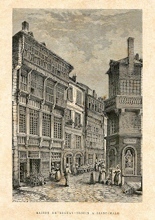
Number 2 Rue de la Corne de Cerf marks the spot where an old house with a wooden façade with stained glass windows was in the 16th century, which was destroyed in 1944, and where the famous corsair René Duguay-Trouin (Saint-Malo 1673 - Paris 1736) was born. He became famous for taking Rio de Janeiro in 1711 and became a Naval Lieutenant General. His remains were brought to Saint-Malo from Paris in 1973.

La Croix du Fief

Écouter le commentaire audio :


La Croix du Fief  marquait autrefois une des limites du « fief », c’est à dire du domaine relevant de la seigneurie commune de l’évêque et des chanoines du chapitre de la cathédrale.

Cette croix était proche de la poterne du même nom qui était l’une des entrées dans l’enceinte primitive de la ville.

Après le premier grand incendie de la ville en 1661,   l’ancienne anse du Fief dite aussi de Merbonne, fut partiellement comblée ; et le reste en 1708-1709,  lors des travaux du premier accroissement de la ville. Cette extension nouvelle permit de créer le quartier de l’actuelle rue Saint-Vincent avec sa porte et de remplacer une partie de l’enceinte primitive.

Au numéro 2 de la rue de la Corne de Cerf,  s’élevait avant 1944 une curieuse maison à façade de bois ornée de sculptures et de vitraux peints, du 16e siècle,    dans laquelle naquit le fameux corsaire René Duguay-Trouin (Saint-Malo, 1673 – Paris, 1736). Sa prise de Rio de Janeiro en 1711 et ses mémoires l’ont rendu célèbre.  Ses restes furent ramenés de Paris à Saint-Malo en 1973 et déposés à la cathédrale.

La Poissonnerie


The Place de la Poissonnerie (Fish Market Square), as well as the buildings around it, were all rebuilt after World War II.
The covered fish market is a work by the architects H. Auffret and J. Ardouin (1954) and the sculptor François Pellerin (Cancale 1915 - Rennes 1998), who won the first Grand Prix de Rome, within the context of an order from the Co-operative Association for the Reconstruction of Saint-Malo, chaired by the Mayor, Guy La Chambre.
The entrance to the covered market is a sculpture called L’Orbiche, which depicts a spiny dogfish in the shape of a small shark. It was restored in 2006.
The internal framework, which is evocative of the interior of a Breton chapel, is also sculpted in the shape of fishes, with simple geometric styling emphasised using black.
Right around the building, the beams above the fishmongers’ stalls feature an inscription engraved in the form of a light-hearted quatrain:
THE SEA CARRIES US
THE TIDE CARRIES US OFF COURSE
THE FISHERMAN TAKES US AWAY
IT IS HERE THAT HE HAS TAKEN ME

In the alcove on the corner of the building, there is a reproduction of a sculpture found there in 1944 depicting La Moune or an ugly woman holding a baby in her arms, which relates to an event that occurred in the neighbourhood.